Katy and Houston-Area Communities Are Sinking: How Scientists Measure the Ground Beneath Us
By The Katy News Staff
Published July 25, 2026
KATY, Texas — Katy’s rapid growth is visible above ground, but scientists are also documenting a slower and largely invisible change beneath the community: portions of the Katy area are sinking.
The process is called land subsidence, the gradual lowering of the ground’s elevation. It is affecting parts of Katy, Fulshear, Cypress, Tomball, Spring, The Woodlands and other communities across northwestern Harris and northern Fort Bend counties.
The latest monitoring does not mean that every home or neighborhood is sinking at the same rate. Subsidence can vary significantly from one monitoring location to another depending on groundwater use, geology and distance from large water wells.
However, the regional measurements show that the movement is real, continuing and—in areas where underground clay layers have permanently compacted—largely irreversible.
How Much Has Katy Sunk?
A Global Positioning System monitoring station identified as P029, located in the Katy area, recorded approximately 35 centimeters—or nearly 14 inches—of subsidence between 2007 and 2025, according to a 2026 public-hearing presentation from the Harris-Galveston Subsidence District.
The station’s average rate from 2021 through 2025 was approximately 2.64 centimeters per year, equivalent to slightly more than one inch annually.
The final 2025 Harris-Galveston Subsidence District report found that the region’s highest measured subsidence rate occurred at a monitoring station in the Katy-Fulshear area and exceeded 3 centimeters per year, or about 1.2 inches annually.
Those measurements represent specific GPS locations, not a uniform rate for every property in Katy or Fulshear.
The difference is important. A house several miles from a monitoring station cannot automatically be assumed to have experienced the same amount of movement.
Which Other Communities Are Sinking?
Active subsidence has been measured across portions of:
- Katy
- Fulshear
- Cypress
- Tomball
- Spring
- The Woodlands
- Northwestern Harris County
- Northern and northeastern Fort Bend County
The latest Fort Bend Subsidence District analysis found rates exceeding 2 centimeters per year in northeastern Fort Bend County near the Harris and Waller county boundaries. Another area near the Brazoria County boundary also showed elevated movement.
By comparison, southern portions of the district’s Regulatory Area A and all of Regulatory Area B recorded relatively minor subsidence, generally below half a centimeter per year.
The pattern shows that subsidence does not follow city limits. Katy itself spans Harris, Fort Bend and Waller counties, while the larger Katy area includes numerous unincorporated neighborhoods and utility districts.
A monitoring station may therefore be described as “Katy” even if it is outside the incorporated City of Katy.
Why Is the Katy Area Sinking?
The primary regional cause is heavy groundwater withdrawal.
Much of Greater Houston sits above the Gulf Coast aquifer system, which contains layers of sand, silt and clay. Water fills spaces within those underground materials and helps support pressure inside the aquifer.
When large amounts of groundwater are pumped from wells, the water level and pressure inside the aquifer can decline.
Sand layers generally resist compression, but fine-grained clay and silt layers can compact as pressure falls. The spaces between the particles become smaller, lowering the land surface above them.
The U.S. Geological Survey describes the process as aquifer-system compaction caused by groundwater withdrawal.
Some seasonal movement can reverse when aquifer levels recover. Permanent clay compaction generally cannot.
Growth Increases the Demand for Water
Katy, Fulshear and nearby unincorporated areas have added thousands of homes, businesses, schools and residents.
Every new development requires water. In areas that continue relying heavily on groundwater wells, population growth can increase the amount pumped from the aquifer.
Water demand also rises during hot, dry periods when residents irrigate lawns, refill pools and maintain landscaping.
The Harris-Galveston Subsidence District reported that its Regulatory Area 3—which includes northern and western Harris County—used approximately 194 million gallons of groundwater per day during 2025.
That area accounted for most of the district’s groundwater withdrawal and includes many of the locations experiencing active subsidence.
By contrast, older areas closer to Houston and the coast have shifted more of their supply to surface water. Those areas now generally record little subsidence and, in some locations, slight land-surface uplift as groundwater levels recover.
How Do Scientists Know the Ground Is Moving?
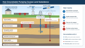
Groundwater pumping lowers aquifer pressure, causing clay and silt layers to compact and the land surface to sink. Scientists track the movement with GPS, satellite radar, extensometers and monitoring wells.
Subsidence is measured using several independent technologies. Each tool answers a different question.
| Measurement tool | What it measures | Why it matters |
|---|---|---|
| GPS monitoring station | Changes in a precise point’s horizontal and vertical position | Establishes how quickly the land surface at that location is rising or sinking |
| Borehole extensometer | Compaction between the surface and a deep underground reference point | Shows how much sinking is caused by compression inside an aquifer |
| InSAR satellite radar | Changes across large areas between satellite passes | Reveals movement between widely spaced ground stations |
| Groundwater observation well | Changes in water levels and aquifer pressure | Helps connect groundwater pumping with subsidence |
| Pumpage meter and reports | The volume of groundwater withdrawn | Identifies where demand may be stressing the aquifer |
| Precision leveling | Elevation differences along established survey routes | Provides long-term comparisons with historical benchmarks |
| LiDAR | Detailed surface elevation from laser measurements | Maps terrain, drainage patterns and elevation changes |
Scientists compare the results from these tools instead of relying on a single measurement.
GPS: Measuring Movement at a Fixed Point
The Houston region has one of the country’s most extensive subsidence-monitoring networks.
Known as HoustonNet, the network includes stations operated by the Harris-Galveston Subsidence District, Fort Bend Subsidence District, University of Houston, Texas Department of Transportation, USGS and other agencies.
Nearly 190 GPS stations across Southeast Texas contributed data to the Harris-Galveston district’s 2025 report. The broader network contains additional sites operated by regional partners.
These are not ordinary navigation devices like those in a vehicle or cellphone. Geodetic GPS receivers use signals from multiple satellites and long observation periods to calculate a station’s position with extremely high precision.
Some stations collect data continuously. Others are operated periodically, often for a week every two months.
Scientists then plot the station’s vertical position over time. A statistically calculated best-fit line through several years of measurements produces an estimated annual subsidence rate.
Using multiple years helps reduce the influence of short-term changes, equipment noise and seasonal movement.
Extensometers: Measuring Underground Compaction
A borehole extensometer is anchored hundreds or thousands of feet underground.
The deep anchor provides a stable reference point. Instruments measure how the land surface moves relative to that anchor.
If the surface moves downward while the deep reference remains stable, scientists can calculate how much material between those points has compacted.
Some monitoring sites contain two extensometers anchored at different depths. Comparing them can help researchers determine whether compression is occurring in shallow or deeper portions of the aquifer system.
The USGS has operated deep borehole extensometers across the Houston region since the 1970s and early 1980s. These instruments have produced decades of information about compaction in the Chicot and Evangeline aquifers.
The Katy-area monitoring system has included GPS and extensometer equipment to help separate surface movement from underground aquifer compression.
InSAR: Measuring Subsidence From Space
Interferometric Synthetic Aperture Radar, commonly called InSAR, uses radar images collected by satellites.
A radar instrument sends radio waves toward Earth and records the signal reflected to the satellite. Scientists compare images of the same location taken at different times.
Small changes in the distance between the satellite and the ground create measurable differences in the returning radar signal.
When atmospheric interference and other sources of error are carefully processed, InSAR can detect ground movement at centimeter or even millimeter scales across a broad area.
This allows researchers to see what is happening between GPS stations.
The Harris-Galveston and Fort Bend subsidence districts have used European Sentinel-1 satellite data to map regional surface movement. The InSAR results generally support the GPS findings: relatively little movement in areas that have transitioned from groundwater and higher subsidence across western and northern areas that remain more dependent on wells.
InSAR does have limitations. Dense vegetation, atmospheric moisture and changes to the ground surface can reduce accuracy. Scientists therefore verify satellite results against GPS and other ground-based measurements.
Groundwater Wells Explain What Is Happening Below
USGS and local districts regularly measure water levels in wells screened at different depths within the Gulf Coast aquifer system.
The water level in a tightly cased well indicates the pressure within the aquifer. When levels decline substantially, the aquifer may be experiencing increased stress from groundwater withdrawal.
Researchers compare those measurements with pumping records, GPS movement and extensometer readings.
That combined approach helps establish the sequence:
- Groundwater demand increases.
- More water is pumped from the aquifer.
- Aquifer pressure and water levels decline.
- Fine-grained sediments compact.
- The ground surface moves downward.
Not every water-level decline produces the same amount of movement. Local geology determines how much compressible clay or silt is present.
Does Subsidence Cause Home Foundation Problems?
Regional subsidence is different from ordinary foundation movement.
A broad area sinking at nearly the same rate may not immediately crack every building. Problems become more likely where the movement is uneven, where underground faults are active or where a structure experiences local soil expansion and contraction.
Houston-area clay soil also shrinks during dry conditions and swells when wet. That shallow soil movement can damage foundations independently of deeper aquifer-related subsidence.
A foundation crack alone does not prove that regional groundwater withdrawal caused the damage.
Property owners concerned about movement should consult a licensed structural engineer or geotechnical professional. A contractor’s sales inspection is not a substitute for an independent engineering evaluation.
How Subsidence Can Increase Flood Risk
Even when a building remains structurally sound, changes in elevation can affect water movement.
Subsidence can:
- Reduce the slope of stormwater channels.
- Change how creeks and bayous drain.
- Lower neighborhoods relative to surrounding land.
- Reduce the effectiveness of drainage infrastructure.
- Alter floodplain boundaries over time.
- Increase vulnerability near rivers, reservoirs and coastal waters.
- Damage roads, bridges, pipelines and well casings.
The greatest concern is often differential subsidence, when one location sinks faster than a nearby area.
A difference of one inch may appear small, but repeated annually over many years it can alter drainage relationships across a rapidly developing watershed.
Subsidence does not create every flood, nor does it automatically mean a neighborhood will flood. Rainfall, drainage capacity, development, soil conditions and proximity to waterways remain major factors.
Houston Has Seen What Severe Subsidence Can Do
The region’s most dramatic historical example occurred near Baytown.
Parts of the Brownwood subdivision experienced approximately 10 feet of subsidence over several decades. Lowering of the land increased the community’s exposure to coastal flooding and storm surge.
Extensive damage from Hurricane Alicia in 1983 ultimately contributed to the neighborhood’s abandonment and conversion into the Baytown Nature Center.
That degree of current sinking is not being reported in Katy. The Brownwood example demonstrates why regional officials began regulating groundwater withdrawals before similar damage could spread.
Can the Sinking Be Stopped?
Previously compacted clay generally cannot be expanded back to its original thickness. The goal is therefore to slow or stop additional subsidence.
The most effective regional strategy has been reducing dependence on groundwater and replacing it with:
- Surface water from rivers and reservoirs
- Reclaimed water
- Water-conservation programs
- More efficient irrigation
- Reuse by industrial and commercial customers
- Coordinated regional water infrastructure
Areas of Harris and Galveston counties that transitioned away from heavy groundwater use now experience little to no subsidence.
Regulatory Area 3 is scheduled to reduce permitted groundwater use to no more than 20% of total water demand by 2035. Large water providers are investing in pipelines, treatment systems and surface-water projects to meet that requirement.
What Residents Should Understand
The latest findings do not mean that Katy is about to disappear or that every house has sunk 14 inches.
They show that:
- Specific Katy-area monitoring stations have recorded substantial long-term movement.
- The highest current rates are concentrated in parts of the Katy-Fulshear area.
- Active subsidence also extends into Cypress, Tomball, Spring and The Woodlands.
- Groundwater withdrawal is the principal regional cause.
- Sinking varies by location and should not be assigned uniformly to individual properties.
- GPS, extensometers, observation wells and satellite radar independently support the findings.
- Reducing groundwater use has successfully slowed subsidence elsewhere in the Houston region.
The sinking is gradual, but the measurements make it visible. For a region adding homes, roads and drainage infrastructure at a rapid pace, understanding what is happening underground is essential to planning safely above it.