Bertha Weakens Near Houston; Fort Bend Flood Warning
Coastal tropical storm warnings have been discontinued, but dangerous rainfall and localized flooding remain possible across the Houston area Thursday night. 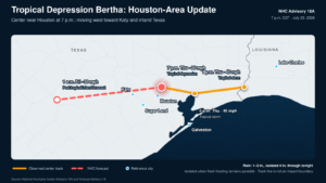
By Staff Editor
Updated: July 23, 2026, at 7:40 p.m. CDT
KATY, Texas — Bertha weakened from a tropical storm to a tropical depression Thursday evening as its center moved into the Houston area, but heavy rainfall continued creating dangerous conditions across parts of Fort Bend and Harris counties.
At 7 p.m. CDT, the center of Tropical Depression Bertha was located approximately 10 miles north-northeast of Houston. The system had maximum sustained winds of 35 mph and was moving west at 13 mph, according to the National Hurricane Center’s 7 p.m. update.
The National Hurricane Center discontinued the remaining tropical storm warning from Louisiana to Sargent, Texas. There are now no coastal tropical storm watches or warnings associated with Bertha.
However, forecasters stressed that Bertha’s downgrade does not immediately end the threat. Heavy tropical rain, urban flooding, hazardous surf and occasional strong wind gusts remain possible Thursday night.
Bertha moves through the Houston area
Bertha made its second Gulf Coast landfall Thursday near the Texas-Louisiana border before moving west across eastern Texas.
At 4 p.m., the center was approximately 35 miles north of Galveston with maximum sustained winds of 40 mph. By 7 p.m., the poorly organized circulation had moved into the Houston area and weakened below tropical-storm strength.
Bertha was moving west toward western Harris County Thursday evening. If the circulation maintains that general motion, its center would pass north of Katy before continuing farther inland. Because Bertha’s center has repeatedly shifted or reformed, residents should focus on active rain bands and local warnings rather than the exact center line.
Additional weakening is expected, and the National Hurricane Center said Bertha will likely dissipate Thursday night.
Flash flood warning issued in Fort Bend and Harris counties
As Bertha moved inland, thunderstorms produced intense rainfall over portions of Fort Bend and Harris counties.
The National Weather Service issued a flash flood warning Thursday evening for east-central Fort Bend County and portions of Harris County. The warning included Sugar Land, Missouri City, Stafford, First Colony and nearby communities and was scheduled to remain in effect until 9 p.m.
Between 3 and 4 inches of rain had already fallen in portions of the warned area. Rainfall rates between 2.5 and 4 inches per hour were possible, with another 1 to 3 inches potentially falling in locations repeatedly affected by thunderstorms.
Emergency crews were responding to reports of stranded vehicles near U.S. 59 and Texas 6 in Sugar Land, according to local reports.
A broader flood advisory also covered portions of Brazoria, Fort Bend and Harris counties, including Richmond, eastern Rosenberg, Pecan Grove, Mission Bend and surrounding communities.
The National Weather Service forecast page for First Colony listed both the flood advisory and flash flood warning Thursday evening.
Is Katy included in the flash flood warning?
The City of Katy was not among the communities specifically named in the flash flood warning at the time of this update.
However, Katy residents should continue monitoring alerts as Bertha’s weakening circulation moves west across the Houston region. Additional showers and thunderstorms could develop quickly, and a concentrated rain band could cause street flooding even outside the original warning area.
Residents traveling from Katy toward Sugar Land, Stafford, Missouri City or Houston should check road conditions before leaving. Flooded intersections and underpasses may remain dangerous after the heaviest rainfall ends.
Never attempt to drive through a flooded roadway. Water may be deeper than it appears, and moving water can carry away a vehicle.
How much more rain could fall?
The National Hurricane Center forecasts general rainfall totals of 1 to 3 inches along the Texas Gulf Coast and South Texas, with isolated totals reaching 4 inches through Thursday night.
Some communities have already received higher localized amounts because of slow-moving thunderstorms embedded within Bertha’s circulation.
The greatest concern is not necessarily widespread regional flooding. Instead, the risk comes from intense rainfall falling over small urban areas faster than streets and drainage systems can carry the water away.
Why did Bertha’s path shift toward Houston?
Bertha remained highly disorganized as it traveled along the Gulf Coast.
Most of the storm’s thunderstorms developed south and southwest of its circulation center. The center also became stretched and difficult to track, with forecasters noting that it could reform in another location.
That unusual structure allowed Bertha’s estimated center to move farther north through eastern Texas than the forecast path suggested Wednesday night.
The National Hurricane Center said the system may already be opening into an elongated trough rather than maintaining a well-defined tropical circulation.
Coastal conditions remain dangerous
Although tropical storm warnings have been discontinued, gusts near tropical-storm strength could continue along the upper Texas coast for several hours.
Water levels may also remain elevated along the Texas and Louisiana coast through another high-tide cycle before gradually subsiding.
Swells generated by Bertha will continue producing dangerous surf and potentially life-threatening rip currents along Gulf-facing beaches Thursday night. Visitors should remain out of the water where beach warnings or red flags are posted.
What should residents do Thursday night?
Residents across Katy, Fort Bend County and the Houston area should:
- Keep weather alerts enabled.
- Avoid unnecessary travel through flooded areas.
- Never drive around barricades.
- Stay away from drainage channels and swollen bayous.
- Move vehicles from streets known to flood.
- Report flooded roads or stranded motorists to local authorities.
- Continue monitoring warnings even after Bertha dissipates.
A tropical depression can still produce dangerous flooding. The storm’s classification measures wind speed, not the intensity of every thunderstorm or rain band surrounding it.
What happens next?
Bertha is expected to continue moving west across the Houston region Thursday night while weakening.
The system will likely lose its remaining organized circulation overnight. Hotter and generally drier summer weather is expected to return after Bertha’s moisture moves away, although isolated showers could linger in parts of Texas.
The National Hurricane Center’s next complete advisory is scheduled for 10 p.m. CDT.
The Katy News will continue monitoring Bertha, flooding conditions and weather alerts affecting Katy and Fort Bend County.