
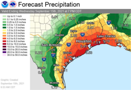
 The Harris County Office of Homeland Security & Emergency Management (HCOHSEM) is monitoring a tropical wave entering our area beginning late Saturday night and lasting into early next week. The National Weather Service forecasts widespread rainfall of up to 3 to 5 inches for areas south of I-10, with the possibility of up to 8 inches in areas closer to the coast.
The biggest threat will come from heavy downpours that produce high amounts of rain in a very short time. This can cause street flooding and rises along rivers, streams, and bayous in areas where this occurs. You can track bayou conditions and sign up for alerts at the Harris County Flood Control’s Flood Warning System website.
Residents are encouraged to monitor weather forecasts through the weekend. Once rains begin, motorists should exercise caution – slow down and leave additional space between you and other vehicles. If you must drive, remember: Turn Around Don’t Drown! Do not drive your vehicle through flooded roadways. Check the Houston TranStar live traffic map for information on road conditions and flooded main lanes in the region.
We are also monitoring potential tropical development in the western Gulf of Mexico and the Atlantic Ocean. ReadyHarris will provide updates via social media channels and, if needed, Ready Harris Alerts.