
 “Not only is there a likelihood of life-threatening flash flooding during the event but also a slow-motion disaster brought on by rising river levels. High water may take days if not a week or more to recede below flood stage,” AccuWeather Senior Meteorologist Alex Sosnowski said.
AccuWeather Global Weather Center – May 19, 2021 – With heavy rain pounding the South Central states day after day, rainfall amounts have soared to historic levels as residents gear up for more severe weather and damaging and life-threatening flooding throughout the week.
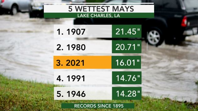
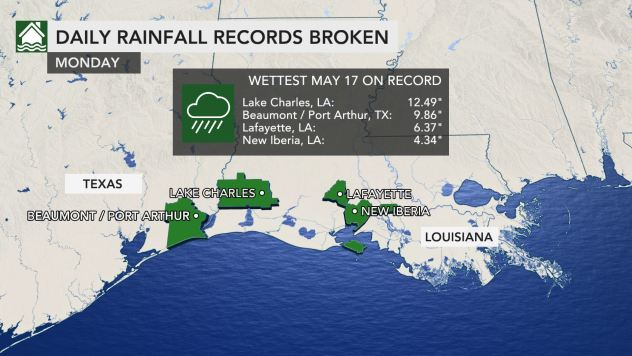
This is already the third-wettest May in recorded history for Lake Charles, Louisiana. The city has received more than 16 inches as of May 19, which is nearly six times the average amount of rainfall during the first 18 days of the month.
A total of 12.41 inches of that fell on Monday alone, which the third-highest single-day rainfall total in Lake Charles’ history.
 “Rounds of rain and thunderstorms have inundated much of the south-central U.S. since Monday, especially for many in Texas and Louisiana, and relief is not expected until late this week,” said AccuWeather Meteorologist Adam Sadvary.
The National Weather Service office in New Orleans issued a Flash Flood Emergency for the southern portion of East Baton Rouge, Louisiana, on Monday night.
Parents were seen bringing their children home from school via kayak and canoe as the streets were flooded across southern Louisiana. Boat evacuations were underway early Tuesday morning in flooded parts of Baton Rouge.
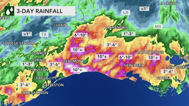 Intense rainfall is not likely to let up across the South Central states as the week progresses either.
A slow-moving disturbance tracking eastward through the Southwest will act as a trigger for daily storm activity from the Rockies eastward across Kansas, Oklahoma and Texas through midweek, according to AccuWeather Lead Long-Range Senior Meteorologist Paul Pastelok.