
What is the danger?
The Harris County Office of Homeland Security & Emergency Management (HCOHSEM) is monitoring potential severe weather beginning Saturday that could cause flooding in the region. The National Weather Service (NWS) has issued a Flash Flood Watch for Harris County from 4:00 a.m. Saturday through 7:00 p.m. Saturday evening.
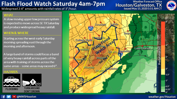 According to the NWS, a complex of thunderstorms is expected to move from west to east across Harris County beginning Saturday morning through Saturday evening. Rainfall amounts of 2 to 4 inches with isolated totals of more than 6 inches are possible. Areas that experience heavy rainfall of more than 3 inches in a short period of time could see potential street flooding. Rises on area creeks and bayous may be possible.
What you should do:
STAY HOME
- Stay home during severe weather, when possible.
DRIVE SAFE
- If you must drive, stay safe:
- NEVER drive into flooded roadways.
- It only take 6 inches of moving water to move a vehicle.
- Have lights and wipers on.
- SLOW DOWN and allow extra braking distance.
- NEVER drive into flooded roadways.
IF THUNDER ROARS, GO INDOORS!
- Postpone outdoor activities.
- If you are outside during a thunderstorm, seek shelter immediately.
- Go inside a building or covered structure.
- Avoid trees and metal objects if shelter is not available.
BE INFORMED
- Monitor the weather throughout the weekend.
- Get updates from trusted sources such as: National Weather Service Houston-Galveston, Harris County Flood Control District, and ReadyHarris.
Text CV19 to 888777 to receive COVID19 updates.
Where you can learn more:
- Local Weather: National Weather Service Houston-Galveston
- Road Conditions: Houston TranStar