
The Harris County Flood Control District has added inundation mapping to the Harris County Flood Warning System, providing a new tool to help emergency management officials and residents make safety decisions during flooding events. Information is posted on the Harris County Flood Warning System website (www.harriscountyfws.org).
Inundation mapping provides information about areas of current bayou and channel flooding, based on information collected by Flood Warning System gauge stations strategically placed along Harris County bayous and their tributaries. This information is used by the Flood Control District and by Harris County’s Office of Homeland Security and Emergency Management to inform the public of estimated flooding impacts across the county.
The new inundation mapping tool is not intended as a notification system for the issuing of flood watches, warnings or evacuations. Instead, the estimated inundation data is provided to help residents and emergency management officials make critical decisions that may ultimately reduce the risk of property damage, injuries and loss of life.
Residents are encouraged to familiarize themselves with the Flood Warning System and its new inundation mapping tool, and to monitor inundation levels during times of heavy rain near their homes, schools, work places and daily commuting routes. Users may type in their address to find the gauge nearest their home or other area of interest.
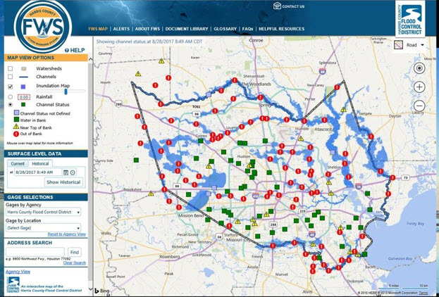
The new inundation mapping tool generates a map of flooded areas adjacent to Harris County bayous and creeks where the Flood Warning System has water level gauges. The tool runs continuously to provide live inundation mapping during a flood, though the results may be as much as 15 minutes behind real time due to the time required to generate mapping from the gauge data. The tool also offers an estimate of inundation levels for rain events dating back to 2015.
Inundation mapping is shown to a zoom level of 500 feet and above. The map depicts the current extent of flooding, but does not include water depth. The mapping tool will only generate a new map if the gauge data for water levels changes by one-half foot. Also, damage to gauges during a flood may affect the accuracy of the flooding estimate and inundation mapping in the vicinity of the damaged gauges.
The new mapping tool does not show all flooding that may occur. This map will not depict flooding from:
- Channels and tributaries without gauges
- Ponding, which may occur during or after intense rainfall when water gathers in low-lying areas, such as in streets when the capacity of the storm sewer is exceeded.
- Sheet flow, which occurs when intense local rainfall flows overland to reach a channel. Frequently, this condition exists when water “ponds” in the streets deep enough to flood residences that are not even near a creek or bayou. The water will seek a path to the channel by flowing overland, flooding residences and other structures that are in that path.
Harris County does not assume liability for the misuse or misinterpretation of any data included within this map. Use of these materials constitutes acceptance of this disclaimer of liability.
HOW IT WORKS
- Go to www.harriscountyfws.org on your desktop or mobile device.
- The “MAP VIEW OPTIONS” section at the top left allows you to add inundation mapping and other features to the county map. (When there has been no rainfall, the inundation mapping feature will not be available.)
- Go to the “ADDRESS SEARCH” box in the lower left column and type your address.
- The map will zoom to the gauge station nearest to your location of interest. The icon shows the amount of rainfall (in inches) received at that location in the past 24 hours.
- Click on the gauge station icon for more detailed information.
- Other “MAP VIEW OPTIONS” allow you to add watershed boundaries, drainage channels and channel status icons to the county map. You can also change the setting in the “RAINFALL DATA” section to see rainfall during various time periods.
- An instructional video that shows how to use the entire Flood Warning System, including the new inundation mapping tool, is available on Flood Control’s YouTube page at: https://youtu.be/eb4AFIspQSQ.